Aerial photo of Tracton area
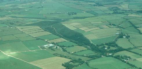
Here's an aerial photograph that Archbishop Coveney
(Apostolic Nuncio to the South Pacific) sent to Bill Coveney of the
Coveney farms at Granig, Boardee and Tubrid, Tracton parish.
If you go to the bottom left of the picture, you will see a cluster of farm buildings. With them is a house that has a darker roof and a winding path leading to it. That is where my sister Mary lives. So all the land thereabouts belongs to Granig townland.
You will also notice the rather steep escarpments separating Granig (on the left) from Tubrid (on the right) and Boardee (to the north).
The afforestation of these slopes looks still rather recent in the photograph; the trees have grown since then. The roadway along the less steep eastern escarpment was built specifically for the new wood and does not represent an ancient way.
To get from the Old Castle house to the Granig house, one would normally take the road eastward and then down the road that appears in Tubrid townland, and then go west through Tracton "village" (now reduced to just a couple of houses) and up from that road (which leads west from Minane Bridge to Ahane to Tracton to Ballyfeard) to the Granig house. You could also, but this is somewhat longer, go west from Old Castle and then down by the road that you can see on the left.